|
STUDII DE ISTORIE VECHE ŞI ARHEOLOGIE
BIBLIOTHECA ARCHAEOLOGICA
ET HISTORICA CORVINENSIS – IV MUZEUL „CASTELUL CORVINILOR”
ISBN 973-7951-59-X, Editura Nereamia Napocae – Cristian Matos, Hunedoara 2004 Volum îngrijit de: Cristian
C. Roman, Dragoş Diaconescu,
Nicolae Cerişer
Prelucrare
Web: Cosmin Suciu; Powered
by: Institutul pentru Cercetarea Patrimoniului Cultural
Transilvanean în Context European
(IPTCE)
Archaeological
findings in the site of Şeuşa-”Gorgan” (Ciugud
parish, ALBA County). I. MARIUS
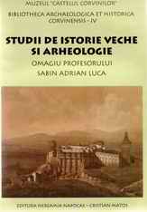
CIUTĂ, ADRIAN GLIGOR* 1. Localization and geomorphologic characteristics The field research carried out in the
surrounding areas of the Şeuşa-”La cărarea
morii” site, that took place in several successive campaigns-both during the archaeological
excavations and between the campaigns[1]-revealed
a series of new points, where archaeological materials belonging to different
historic periods were found (fig. 1). In 1996, during a field research
carried out on the top of a hillock[2]
(at a distance of 1,5 km towards north - north-east of “Cărarea
morii” and 3 km east of the village (fig. 1-2) on the eastern hill side (farm
land), we noticed the presence of a relatively rich quantity of
archaeological materials, especially pottery, which could be framed within a
late phase of the Coţofeni culture, on the basis of the
specific structure and decoration style. The same research revealed the fact
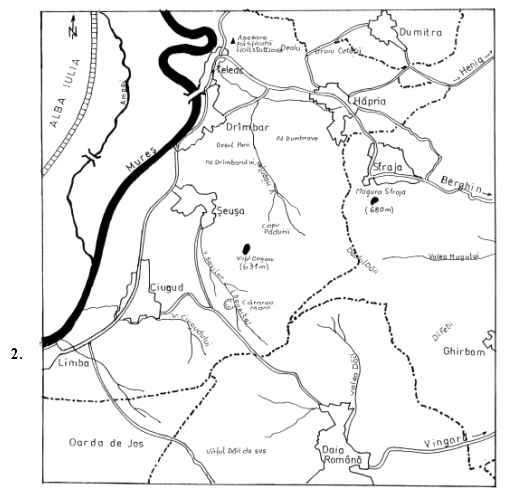
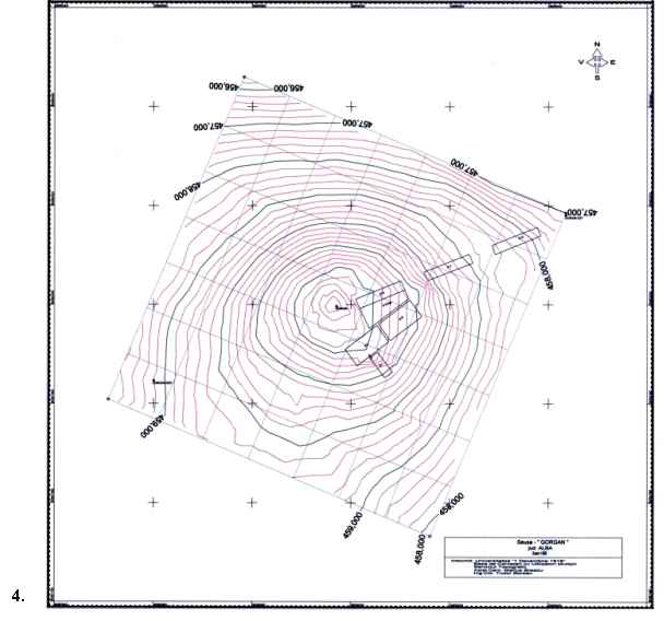
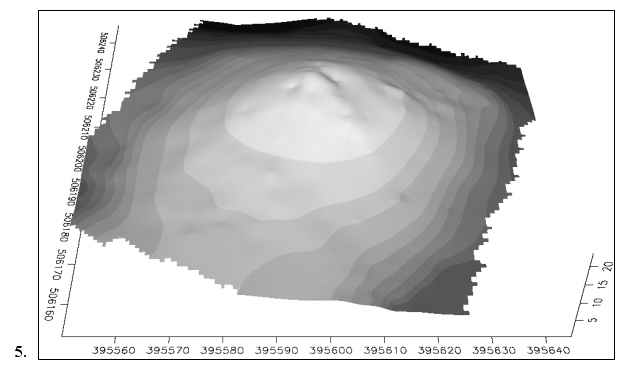
that on the highest point of the hillock (which has an absolute altitude of
463 m; latitude: 46°3’53’’; longitude: 23°39’2’’), there is a
knoll having a diameter of approx. 8-10 m, with a topographic landmark on its
top (fig. 2-4). The etymology of this toponym-“Gorgan” (“The Gorgan top”)[3],
the shape of the land and the presence of the archaeological materials
mentioned above were potential arguments, which at that moment (1996) spoke
for a possible existence of a tumulus probably belonging to the Coţofeni culture in that place. We would like to mention that the traces of two
parallel, covered ditches were visible on the lateral, north-eastern and
south-western sides of the knoll. The form of these ditches seemed to
resemble sections of stratigraphic probing. Following bibliographic research
and consulting fellow archaeologists, we found no mention of past excavations
carried out in this location. We do not exclude either the intervention of
“treasure seekers” or the possibility that the knoll, respectively the
ditches, could be results of certain recent human interventions (these could
have been military arrangements and/or even the placing of the topographic
landmark)[4]. On the
other hand, the stratigraphic situation obtained during the three campaigns
carried out here, corroborated with toponymic and archive information, shed a
new light on the understanding of the morphology of this knoll; this kind of
knolls having the same toponym (quite frequent in this region) used to
represent landmarks between localities in the medieval age.[5] Geomorphologically,
the Gorgan hillock belongs to the contact area between the western Secaşelor
Plateau and the valley of river Mureş, which is, in
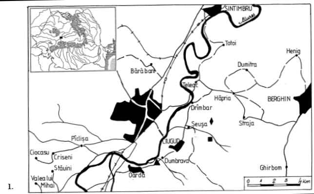
this sector, a wide corridor (fig. 1). Its dominant position offers an
excellent overall view (of the surroundings) over the entire Mureş
valley (from Vinţu de Jos parish to the vicinity of
Teiuş
town, that is more than 30 km), as well as over the entire western and
central part of the plateau (fig. 2). In order to give a better localization
of this point/site, we would like to add that it lies at approx. 3 km
south-west of Măgura
Străjii,
which is the highest point of the western Secaşelor
Plateau, at the at the same distance towards the south from Jidovar top
(which belongs to the Hallstatt fortified settlement of Teleac) and approx. 6
km East of Alba Iulia town (fig. 2-3). The point lies on the border of three
localities: Şeuşa,
Drâmbar
and Hăpria,
all three villages belonging to Ciugud parish. In order to avoid any confusion, we have chosen to carry out
the archaeological investigations in the closest locality that is Şeuşa.
Following the inclusion of this site in the plan of the Pre- and
Protohistorical Research Centre within the University “1 Decembrie 1918” of
Alba Iulia, the approach through systematic archaeological research of the
“Gorgan” point was decided in 2000. 2. The research (2000-2002) The first stage of the effective approach of this
site was the carrying out of a control probing in order to obtain
stratigraphic information[6].
The probing had in view the eastern area of the hillock-characterized by the
highest density of archaeological materials found on the surface-and
identifying the stratigraphic situation in this sector of the hillock was our
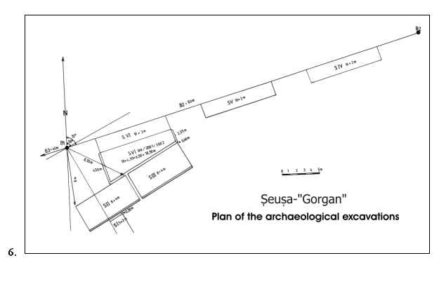
main objective. For this purpose, the first section was opened (S I/2000 = 5
x 2 m), oriented north-west-south-east, situated at 11,40 m towards
south-east of the topographic landmark[7]
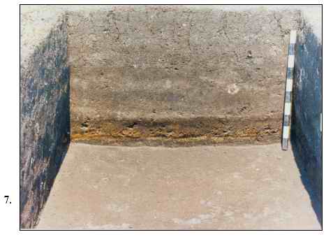
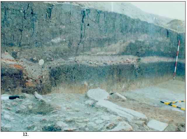
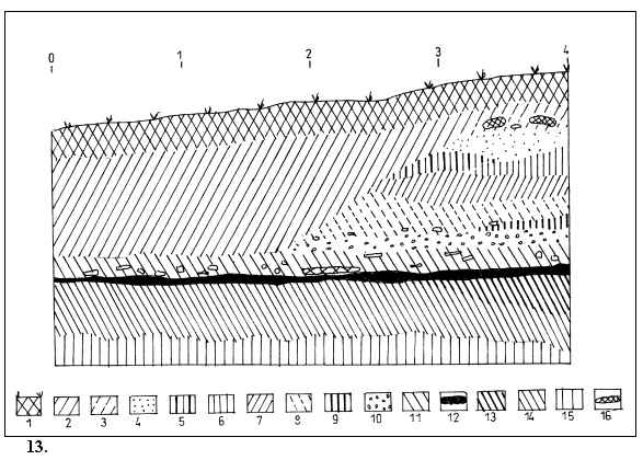
(fig. 4, 6). Up to 1 m deep no complex was grasped, but the archaeological materials discovered in the cultural layer, especially the pottery, spoke for a local existence of a relatively intense occupation of the Coţofeni community, on several levels. At this depth, in the north-western half of this section, we noticed a flat, uniform agglomeration consisting of adobe fragments, red-coloured, with a thickness ranging from 5 to 8 cm; under this agglomeration, we found a similar uniform level of black-coloured burned material (coal) and, under this level, a thin, white-yellowish coloured level (2-4 cm) (fig. 7). The grasping of this complex at the surface, within the section’s profiles (entirely on the north-western and only partially on the south-western and north-eastern profiles) led to the conclusion that we were facing the southern extremity of a burned down surface dwelling (L1/2000). Within the agglomeration that represented the dwelling, a rich archaeological material was found, consisting of ceramic fragments, animal bones, quartzite splinters (rarely flint), bone tools (three sharped, worked pieces) and relatively large burned adobe fragments. The stratigraphic situation we had noticed and the characteristics of the archaeological material allowed us to launch the hypothesis regarding the way the dwelling came to an end, namely through fire[8] (fig. 7). Under this
complex, that marked the lower limit of the Coţofeni
cultural layer, at a depth of 1,2 m, we grasped a darker coloured, more
compact level, with reddish-brick coloured intrusions, in which ceramic
fragments scarcely appeared, totally different from the Coţofeni
ones; this cultural level was quite poor and difficult to delimit on the
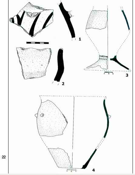
stratigraphic profile (fig. 7). We would like to point out the discovery, in
this last level, of a few ceramic fragments belonging to a beaker with high
leg, decorated with circular impressions,
made with a thin cylindrical tool, apparently belonging to the Tiszapolgár
culture, according to the analogies with its shape and ceramic structure[9]
(fig. 22/3). At the depth of 1,30 m-in the south-eastern extremity-and 1,60 m
in the north-western extremity[10],
under the level corresponding to the “Tiszapolgár type”
occupation, we grasped the archaeological sterile ground, which was
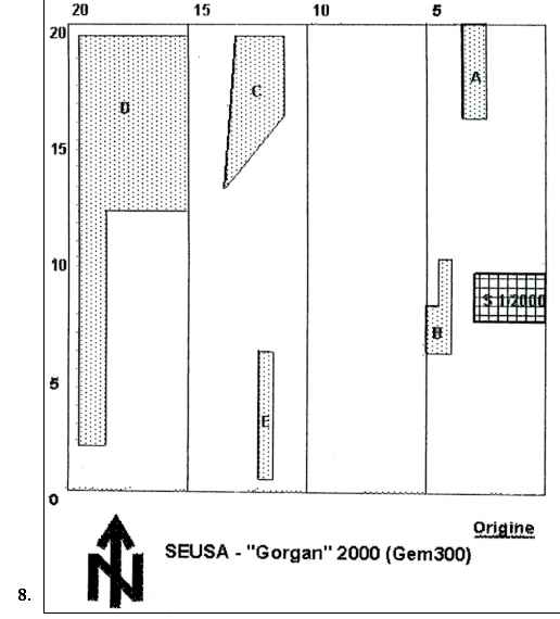
loess-like, clayey, yellow coloured (fig. 7). The second stage of the 2000 campaign[11] was characterized by vaster activities[12]. Our main goal was the complete unveiling of dwelling 1/2000 by opening an adjacent surface to the north-western end of S I/2000 (leaving a 30 cm thick stratigraphic marker). Before the opening of this surface, a magnetometric survey was carried out, in a 400 m2 area (a square, which had a side length of 20 m, having the centre on the topographic landmark)[13]. The result of the prospection proved the existence of several areas with magnetic anomalies that could have been complexes or burned dwellings (fig. 8). The surface S II/2000 = 8 x 4 m was opened
perpendicularly on the direction of S I/2000, north-east-south-west oriented[14]
(fig. 4, 6). The level difference corresponding to the long sides, relatively
parallel with the hillock’s contour lines, ranged between 30-40 cm. In
squares 5 and 7 (in the higher area, close to the topographic landmark), at a
depth of 0,50 m, a new Coţofeni surface dwelling (L2/2000)
was partially revealed. This dwelling was characterized by the presence of a
relatively rich archaeological material, mostly pottery; however, it lacked
the solid basis structure as well as the adobe walls. In the profile, the
dwelling was marked through an ash lens. Then we noticed that the dwelling
had several occupation stages (fig. 9/3-4, 7). More precisely, these could
have been previous arrangements (reconstructions) of the dwelling. This
situation could be later revealed, following the stratigraphic profiles from
the south-western corner of the surface, that showed the arrangements of the
complex (more exactly, of the complexes), characterized by a short-lived
(probably seasonal) occupation, that usually ended through fire[15]
(fig. 9). In the northern area of the surface, in squares 1-2-3, a new dwelling (L3/2000) was revealed at a depth of 0,80 m, and in squares 4-6, in the same level, another dwelling (L3bis/2000) was grasped, both having the same characteristics with dwelling 2/2000, but lacking re-arrangements (fig. 9/6, 9, 11). The first one (L3/2000) had a relatively rectangular shape (approx. 4 x 2 m) and it was indicated by the burning and ash traces and even burned post holes. The margins of the second dwelling (L3bis/2000) could not be fully grasped, as they remained under the south-eastern profile of the surface. In the north-western corner of S II/2000, in square 1, we noticed a new arranged/laid out structure – an ash lens (2-3 cm), under which lied a thick flat lens (10 cm) of yellow coloured clay. This proved to be a new surface dwelling (L4/2000), in fact its northern corner, as the complex continued under the north-eastern and north-western profiles (fig. 9). In the level
corresponding to dwelling 4, at a depth of 0,90 m, in the south-eastern area
of the surface (the lower one, corresponding to the northern end of S
I/2000-fig. 11/4, 8, 9) and at a depth of 1,30 m in the opposite
(north-western) area, we found dwelling 1 (L1/2000-fig. 9/10, 18;
fig. 13/12), initially identified in S I/2000. In the end, this dwelling
proved to have a rectangular shape and quite large dimensions, of approx. 7 x
4 m, having an east-west orientation[16]
(fig. 10). In SI/2000 we grasped its south-eastern corner and in surface II
we found the rest of this dwelling, thus being revealed over 85-90% of its
entire surface (its north-eastern corner could not be unveiled as the
stratigraphic marker could not be removed) (fig. 10, 11, 13). The dwelling
had the aspect of a large flat agglomeration of burned adobe fragments of
different dimensions-some of them with wattle or wooden posts traces-in some
cases burned until vitrification, ceramic fragments belonging to several
vessels of different dimensions and structure (some burned until
vitrification), osteological material, lithic (chipped, polished etc.)
material, charred wood fragments and so on. Dwelling 1 was built on a wooden
structure and wattle plastered with adobe and came to an end through a strong
fire. On the way in which the walls
collapsed-towards inside or outside-and were fragmented, depended the manner
we revealed the dwelling’s shape using the trowel (fig. 10). In certain areas
there was mostly strong, red-coloured burned material with vitrified adobe
remains and, in other areas, black burned material of charred wood (sometimes
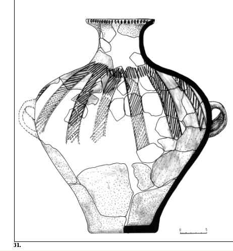
in large pieces), associated with white-coloured ash. The dwelling
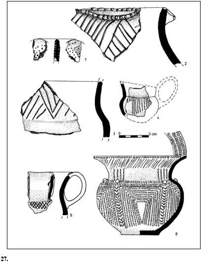
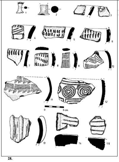
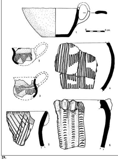
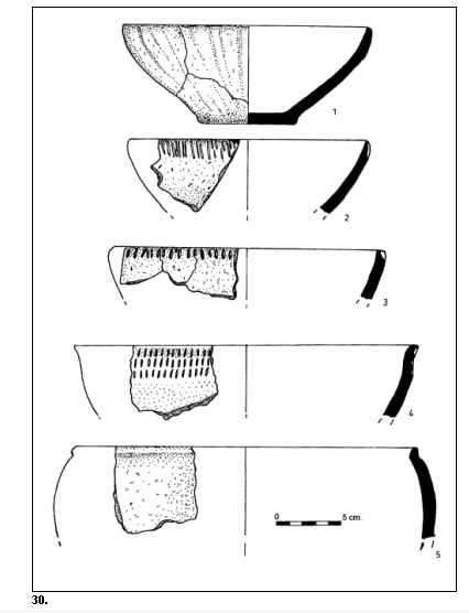
showed a very rich inventory: complete or restorable vessels (more than ten
pieces), fragmentary ceramic material with different decoration techniques
(fig. 27-31), flint and quartzite blades and sharp bone tools. In the
profile, the remains of the dwelling had a thickness ranging between 10 and
30 cm (fig. 9, 11-12-13). On both profiles
of the long sides we noticed two holes. The first one (G1/2000),
grasped in the south-eastern profile (fig. 11) and in which two filling
phases were observed, was placed inside the dwelling and within it we found
three large vessels, broken on the spot, as well as other restorable vessels
nearby (fig. 10). The hole was filled with material resulted from the fire.
The second hole (G2/2000) observed in the north-western profile, was
situated outside the dwelling, had larger dimensions and was bell-shaped
(fig. 9/10). It was characterized by a rich inventory of animal remains, ash
and charred wood and ceramic vessels fragments. The purpose of this hole
seems to have been that of keeping the domestic waste, being covered by the
dwelling’s debris (some of the fragments belonged to vessels within the
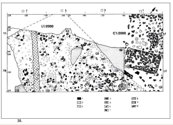
dwelling). In the next
excavation level, in squares 1 and 2, a new cultural layer was outlined,
within which a new complex was revealed (C1/2000), as a flat
agglomeration of burned adobe fragments, grinder fragments and restorable or
even complete ceramic vessels (fig. 10, 14). Remarkable was the discovery,
inside it, of a distinct, massive rectangular structure with 1,5 x 1 x 0,15 m
dimensions, east-west oriented, made of compact burned adobe (slightly
fragmented as a result of earth’s pressure, yet maintaining its initial
shape), having a slightly trough-like upper surface due to a 3-5 cm wide and
probably 5-10 cm high chime, quite poorly preserved,
fragmentary along the margins[17]
(fig. 14-15-16). At its western end we found four diverse shaped grinders
(mill stones) of different dimensions (fig. 16) and in its vicinity (towards
north-west) two complete vessels (fig. 23/1, 4) and one restorable vessel
(fig. 23/5) lying directly on the chime. The vessels’ fragments had specific
decoration (fig. 24/5-7, 9-15) and the shape of the complete vessels
confirmed that the archaeological materials found in this cultural layer
belonged to a “Tiszapolgár type” cultural phenomenon. On the entire surface of the research unit
we grasped the layer corresponding to the complex-the same that was grasped
also in S I/2000 under L1/2000-having a brown-russet colour, with
red-brick coloured mineral intrusions, containing Eneolithic archaeological
materials and being of approx. 30-40 cm thick. In squares 5 and 6, at the
lower part of this level, we noticed a hole (G3/2000) of
relatively large dimensions, having a diameter of 1,5 m and deepened 1 m into
the sterile ground, covered by an external hearth and a grinder. When we
emptied the hole, we noticed that it contained, along fine ceramic material,
brick-reddish coloured, well polished, belonging to a large vessel (fig. 22/4), animal bones and snail
shells (over 50 pieces). On its bottom, directly on the sterile ground, we
discovered a ceramic fragment decorated with dark-coloured painting, quite
poorly preserved, applied on an engobed, white-yellowish background (fig.
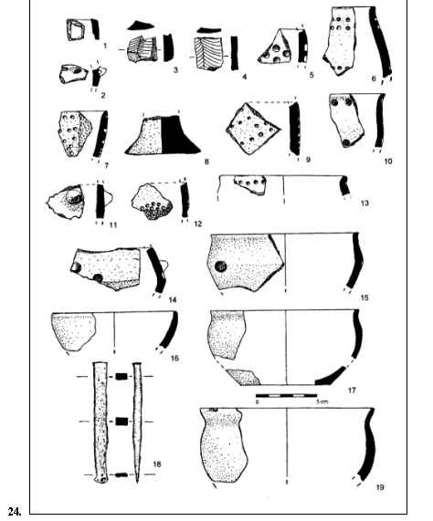
22/1). In square 6,
at a depth of approx. 1,40 m from the contemporary ground level, in the
“Tiszapolgár
type” layer, we discovered a well preserved, small copper chisel, whose
dimensions were 10 x 1 x 0,7 cm (fig. 24/18). It lied at approx. 24 cm under
the lower limit of the Coţofeni surface dwelling (L1/2000),
in the close vicinity (3-4 cm) of the south-eastern profile. The piece did
not belong to any complex; it lied within the cultural layer (the closest
complex corresponding to the cultural layer of this piece was G3/2000).
Revealed as a result of the intense green oxide coat, the small chisel had
the active (sharp) side half-moon-shaped, quite well preserved, with
wearing-out traces, similar to the back side, having also traces of
bevelling, as the result of using this end for percussion. The specific weight confirmed that the core of the piece
was still massive[18].
This small chisel made the object of special investigations[19],
which revealed a high copper purity (96,2 %), as well as the presence of
elements that proved the using of native copper and its “cold” processing[20]. The “Tiszapolgár type” level had a horizontal basis, fact that allowed us to think of the possibility of an initial levelling (terracing) of the land by the community settled here. Under this level lies the sterile ground having a compact, hard structure. The 2001 campaign The first
action undertaken was the complete unveiling of the complex that contained
the probably cultic arrangement (shrine-granary?) belonging to the
“Tiszapolgár type” occupation that remained in situ in the previous campaign, as we lacked then the adequate
means for its removal and bringing to the conservation-restoration
laboratory. Once it was fully unveiled, photos of this structure were taken
from different angles, it was re-drawn, divided on squares encoded with
symbols, then removed, piece by piece, as it could not have been taken out at
once (“in block”)[21].
At the removal of the complex’ fragments, on their internal side we could
notice longitudinal wattle imprints (parallel with the long axis of the
shrine, with a 3-5 cm diameter), which represented the wooded “bed” on which
the clay pasting mixed with a large quantity of organic, vegetal degreasing
substance was most probably placed (fig. 16). The burned adobe was about 15 cm thick towards the margins, where it is
slightly raised in the shape of a chime, while to the middle it decreases to
a thickness of only 2-4 cm, thus the entire complex had a slightly
trough-like aspect[22]
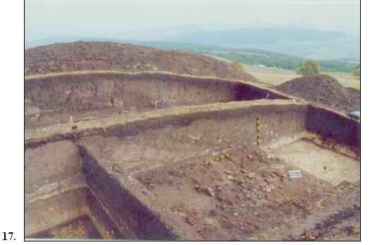
(fig. 15-16). A new surface (S III/2001), with 8 x 4 m dimensions, was opened further towards north-north-east of S II/2000, with a 50 cm stratigraphic marker between the two sections, in order to unveil the partially grasped complexes[23] (fig. 6). The stratigraphic situation was similar to that grasped in S II/2000, as we noticed seasonal Coţofeni occupations in the upper half of the layer belonging to this culture; at the basis of this layer, in squares 5 and 7, we found the continuation of the surface dwelling, L4/2000, which had a rectangular shape, built on a yellowish-green clay “bed” (floor), with a thickness ranging between 5-10 cm (the clay was taken from nearby) (fig. 9). The dwelling was burned down, just as L1/2000, with which it was contemporary. Under L4/2000-2001-respectively the
first Coţofeni
occupation layer-C1/2000 continued. In squares 5-8, on the almost
entire surface of 4 x 3 m, a burned compact adobe agglomeration was revealed,
mixed with large pottery fragments (ewers), restorable and even complete
vessels (six vessels), elements of anthropomorphic and zoomorphic plastics,
lithic flint chipped pieces and grinder fragments (fig. 14, 17-18). Judging
on the aspect of the layout, it seemed possible that it continued under the
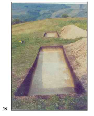
north-western profile (stratigraphic marker). In order to grasp the extension of the prehistoric occupation on the entire area of the hillock, we opened three control-sections on its north-eastern slope in order to obtain stratigraphic information (S IV, S V and S VI/2001, each one with 10 x 2 m sizes, with a 5 m wide stratigraphic marker left between them), having a north-west-south-east orientation. They had the shape of a partial trench, having in view the opening of a cross-trench for stratigraphic information (fig. 6). Due to the terrain’s morphology, in the form of successive terracings, we assumed the existence there of human layouts, on which certain complexes could lie, representing extensions of Eneolithic occupations; we should also have in view that this slope was best protected from winds, having thus natural advantages, offering favourable living conditions. The stratigraphic situation revealed in S IV/2001 and S V/2001, placed exactly on the presumed “terraces”, proved that these configurations are, in fact, natural. Under the vegetation layer, with a thickness ranging between 0,20 and 0,45 cm, containing no archaeological materials, we found the yellow sterile ground similar to that grasped in S I and S II/2000 (fig. 19). We could thus establish that the Eneolithic
occupations of Gorgan were grouped around the top of the hillock (on a radius
of 15-20 m, at most). This cannot stand for a final conclusion, but only for
a current hypothesis based on the current stage of the research – at least
until the western, southern and south-eastern slopes of the hillock will be
probed as well, even if they do not seem to have the same natural advantages
for habitation[24]. The
archaeological layer was clearly grasped only in section VI/2001. Seasonal
dwellings (huts) that had been burned (down) were noticed. These dwellings
were agglomerations of burned adobe without a compact aspect (L6/2001–Coţofeni
culture). Under this layer, at a different depth due to the natural slope,
another surface dwelling was found (L5/2001-2002–Coţofeni
culture); its floor board was partially grasped, as well as remains of the burned
wall, this time having a compact aspect and clearly delimited sides. In order
to completely unveil the dwellings and complexes that were grasped, we
expanded the long (south-eastern) side towards S III/2001 and we left a 50 cm
marker between the two research units. Section VI/2001 became thus a trapeze
(S VIbis/2001-2002) with the sides length of 10 x 4,35 x 6,50 x 10,50 m (fig.
4, 6, 20). The numbering of the initial squares (of section VI/2001) remained
the same (1-5, from north to south) and its
extension towards south-east followed the numbering of the resulting squares,
from north to south (6-10). Objective reasons forced us to stop the
excavations and preserve in situ
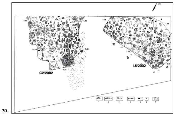
these two dwellings. The 2002 campaignOur attention has been exclusively drawn to the surface VIbis/2001, which became surface SVIbis/2001-2002[25]. The Coţofeni dwelling, named L6/2001-2002, which was grasped in the 2001 campaign in squares 3-4-9-10 of S VIbis, revealed a simple structure of seasonal hut type. Its presence was indicated by a light coloured ash lens, with an irregular form and a thickness of 2-5-10 cm, as well as ceramic materials and quite few animal remains. Its structure was mostly wooden, the small burned adobe fragments being quite rare. This dwelling could also have been burned down. In the north-eastern corner of the surface (squares 1-6-2-7), at a depth of 1,20 m, a new surface dwelling belonging to the Coţofeni culture (L5/2002) had been completely unveiled. Of a relatively rectangular shape, the sides having an approx. length of 3 x 1,8 m, east-west oriented, the dwelling had the aspect of a massive burned adobe agglomeration, with traces of posts and wattle, ceramic fragments, animal remains, stones, fragments of charred wood and a large quantity of ash and so on (fig. 20). At the removal of the materials, we noticed that
many of the vessels were restorable, with frequent traces of secondary
firing. Some of the fragments were burned until they got vitrified. These
arguments make us believe that the dwelling was very probably burned down in
a strong fire, just like L1/2000 and L4/2001,
contemporary with L5/2002; they delimit the basis of the
Coţofeni layer, respectively the earliest occupation of this type at
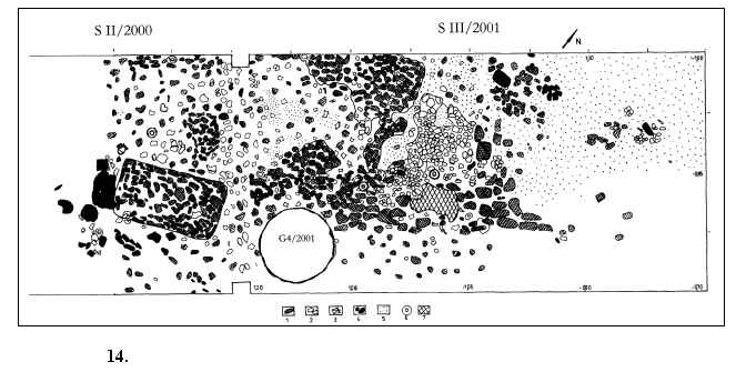
Gorgan. Along squares 4-9-5-10, on the almost entire southern half of the surface, under dwelling 6/2001-2002, at a depth of approx. 1,40 m, corresponding to dwellings 1 and 5, respectively the first occupation level of the Coţofeni culture, we grasped the continuation of dwelling 4 (Coţofeni). Dwelling 4 had been partially grasped in the previous campaigns, in the north-western corner of S II/2000 and south-western corner of S III/2001), thus this became L4/2000-2002. The dwelling was built on a yellow-coloured clay “bed” (floor) (about 5-10 cm thick) and was characterized, as in the part grasped in S III/2001, by a poor material inventory, the floor being covered with a compact ash and charred wood layer (lens) (sometimes over 5 cm thick!). This indicates that the dwelling was very probably burned down as well. A rich inventory of pottery and animal remains was found in the dwelling. A bell-shaped hole (G5/2002), probably belonging to the same dwelling, was grasped as an annex at the limit between squares 5 and 10 and then emptied. This hole had a diameter of approx 1,20 m and a depth of 1,50 m. It contained quite few materials (especially pottery) and on its bottom there was no charred wood lens, which was previously grasped in a complex of similar dimensions and shape (G4/2001 in S III/2001), which also belonged to dwelling 4. The
stratigraphic situations and the complexes revealed in the 2002 campaign
confirmed our previous hypotheses regarding the existence of an initial
occupation (early), stable, long-lasting, of a Coţofeni community in
this point (belonging to the third phase of this culture’s evolution). That
occupation was indicated by surface dwellings of relatively large dimensions,
built upon wooden posts and adobe and levelled clay floors (L1/2000,
L4/2000-2002, L5/2002, fig. 9; 20); these dwellings seem to have come to an
end through a strong fire. The initial occupation was followed by further
seasonal occupations, in wooded huts and,
probably, pit-houses, belonging to the third phase of this culture’s
evolution as well.[26]
The morphology of this site makes possible the framing of the settlement (at
least the one from the first occupation stage) in the so-called category of
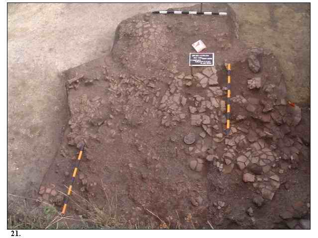
“the high settlements, on terraces”[27]. Under the Coţofeni level, in squares 3-4-8-9 (in the western half of surface VIbis, at a depth of approx. 1,70-1,80 m), a new surface complex belonging to the “Tiszapolgár type” cultural horizon was grasped (C2/2002, fig. 20). This complex was characterized by a massive agglomeration of ceramic vessels of different dimensions, broken on the spot, collapsed burned adobe walls. Outside this agglomeration we found a hearth having a thickness of approx. 4 cm (fig. 20-21). Within this complex, as well as in its near vicinity, grinders and grinder fragments were found, as well as stone crushers. The ceramic vessels found belong to the fine category (small-shaped, bowl type, eight of them) as well as to the rough category (large storage vessels, amphorae and ewers, with horizontally pierced handles, at least four of them). The conservation state of the vessels is very good, one of them being entirely preserved, the rest being easily restorable. Between this complex and the eastern margin of
the surface, where we expected the continuation of the first “Tiszapolgár
type” complex (C1/2000-2001), there was no connection element.
Thus, it has been confirmed that it represents a new surface dwelling, of a
relatively rectangular shape (the complex was not fully unveiled, it
continues under the western profile, fig. 20). This dwelling is quite
similar, in terms of structure and material, to C1/2000-2001;
however, it lacks the cultic layouts and the specific rich decoration
elements[28]. ConclusionsAt the current stage of the research, we can
state that at Şeuşa-“Gorgan” we have an archaeological site with
multiple cultural layers. The settlement situated on the top of the Gorgan
hillock began with communities of the “Tiszapolgár type” cultural horizon,
which were the first to intervene upon this specific micro-area through a
specific terracing needed for habitation. We do not exclude the existence of
a cultic layout on this hillock, related with agricultural practices
(farming), associated with the movement of the stars (the sun) on which
certain sacrifices were offered. Up to this moment we grasped two surface
dwelling complexes, two external hearths and a hole (probably for domestic
waste?) belonging to this occupation level, and a copper piece, discovered in
the cultural layer, close to the shrine-granary. These facts prove a
relatively intense occupation, with a single level grasped stratigraphically. Subsequently-and/or contemporaneous with the final occupation-there took place certain phenomena of cultural mixture, determined by possible contacts with other horizons (Herculane II-III – Cheile Turzii). Chronologically, there follows an end of the occupation in this area, which was stratigraphically grasped in some places, where the stratigraphy was not disturbed through further layouts. The occupation will continue, this time more
intensively, at the beginning of the third phase of evolution of the Coţofeni
culture. In this context, the human occupation of this not quite accessible
top could be easily justified as a result of the subsistence sources and raw
materials present in this area (wood, useful rocks etc.). The drinking water
springs, which are nowadays at a distance of approx. 600 m from the site,
were much closer to the top in those times, as a consequence of the forest
vegetations. We presume that there was a forest in the close vicinity of
Gorgan in the prehistoric times, which covered then the entire surrounding
area and even the mentioned top (the forest exists nowadays as well, but only
on the northern slopes, in the low areas, close to Hăpriţa
valley)[29]. Moreover, the morphological shape of the top must have been flatter, the “pointed” aspect of today being the result of the intense occupations in this place, and probably of the modern placing of the triangulation point. The shape of this land was also exploited by the Coţofeni communities; they systematically terraced the top, continuing the work of the previous settlers. The
succession of the Coţofeni occupations-the first level is
one of intense and stable occupation, with large surface dwellings (L1,
L4, L5) which came to an end through a strong fire, followed
by further occupation levels, the dwellings and the materials suggesting a
seasonal character (L2, L3, L3bis, L6).
The thickness of the Coţofeni layer reaches a maximum of 1,80
m towards the top and decreases as the distance from the top increases. It
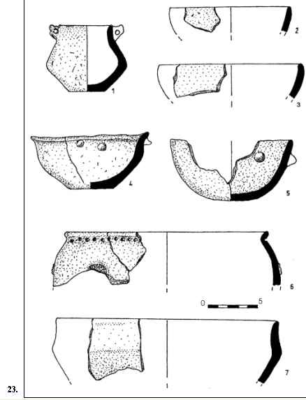
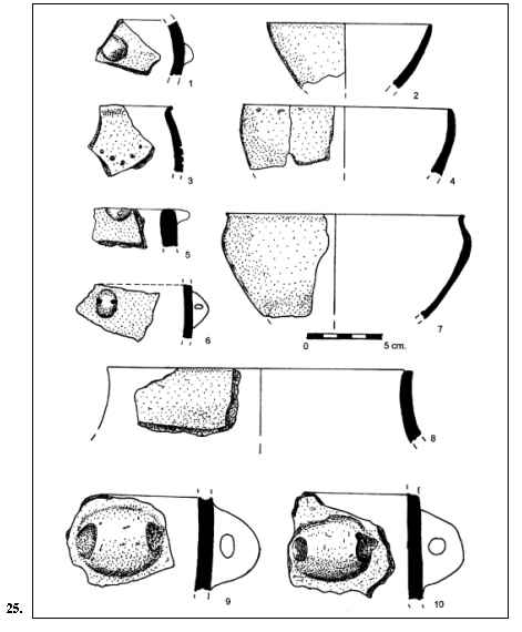
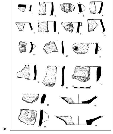
disappears at a distance of approx. 25 m towards east.â Complex 1 (“Tiszapolgár type” horizon)[30] The pottery we found here had a floury aspect,
yet nice, the reddish-yellow, orange colour predominates, the grey one is
rare (fig. 22/3); only one of the vessels has polishing traces (fig. 22/4).
The fine sand was used as a degreasing substance. Regarding the vessels'
shape, there is a large number and a variety of bowls. According to the
typology of Ida Bognár-Kutzián[31]
and largely taken over by Gh. Lazarovici[32],
we have small bowls with slightly rounded body, quite similar to flatter
bowls (străchini)
(fig. 23/2, 3, 5; 24/16, 17, 19; 25/2, 4, 7), which, after their depth, could
be seen as deeper bowls (castroane) (fig. 23/7)[33].
Another variant is represented by the bowls with widened out lip and slightly
carenated shoulder (fig. 23/4; 24/15) or bitronconic with well delimited
shoulder and straight or even slightly narrowed lip (fig. 22/2; 23/7; 24/15;
26/8). We would also like to point out the frequency of the calotte-like
bowls with straight or even slightly narrowed lip (fig. 23/2, 3; 24/16; 25/4;
26/2, 4), as well as those with pouring beak. The larger vessels are framed
within the category of amphorae with large neck (fig. 22/4) or jar-vessels
(fig. 23/6; 25/3, 7). Then there is a miniature vessel, with a bitronconic
shape, with two small handles slightly sharpened, attached to the lip (fig.
23/1), a beaker with high leg, fragmentary (fig. 22/3) and a ceramic fragment
which could be from an anthropomorphic idol of large dimensions or, more
probably, from a beaker-like vessel with leg (fig. 24/8). The vessels' decorations are poor and rigid, there are only in relief ornaments, like conical knobs (fig. 22/4; 23/4, 5; 24/11, 14; 25/1, 5; 26/11) or round buttons (fig. 26/17). The second (and last) type of ornaments are round impressions, placed in horizontal band right under the vessels' lip (fig. 23/6; 24/6, 10, 13), grouped in order to obtain various motifs (fig. 24/7, 9, 12) or angularly placed in order to obtain "V"-shaped motifs (fig. 25/3). We could identify brown painting on two of the fragments (fig. 22/1; 26/1), as well as the slight alveolated shape of the lip of a large vessel fragment (fig. 22/2). The beaker with high leg (fig. 22/3) has good analogies in the late Tiszapolgár settlement from Deva-“Ciangăi”[34], while the small bowls are similar to those found in the inventory of the pit-house from Aiud-“Microraion III”[35], which are dated by the excavator as a component of the Băile Herculane-Cheile Turzii complex, probably as a local facies. The researcher S. A. Luca includes, however, the discoveries from Aiud-“Microraion III” in the Decea Mureşului group[36] and this aspect has to be kept in view for our discovery as well, when we study closely the forms and the ornaments of some of the bowls (fig. 22/2; 23/4-5, 7; 24/14-15, 17, 19; 25/7). This bowls proved strong similarities (shape, structure, technique of decoration and ornaments) with the ceramic pots discovered in the graves nr. 8[37] and nr. 11[38] from Decea Mureşului cemetery. The same conclusion is indicated by the floury
aspect of the pottery, which is smoothed, even polished in most of the cases
of the classic Tiszapolgár phase (this is very rarely seen at “Gorgan”). Regarding the small copper chisel discovered near
C1/2000, the copper processing within the Tiszapolgár culture is
well known on the Romanian territory, as well as in Hungary, Slovakia and
Yugoslavia. The cross-shaped axes discovered in Tiszapolgár settlements or in
settlements of Bodrogkeresztúr mixture are especially well known. On the
other side, in the cemetery from Decea Mureşului where discovered
specific copper pieces, (needles) very similar with the small chisel from şeuşa-“Gorgan”[39]
. Thus, following the detailed and comparative study of the materials provided by the Tiszapolgár complexes (C1/2000-2001), we would like to launch the hypothesis – without definitive cultural and chronological framing of the Middle Neolithic discoveries – that the “Gorgan” occupation is chronologically situated at the end of the Tiszapolgár culture (phase B), close to the mixture stage to the Bodrogkeresztúr culture[40]. However, the shape and the decoration particularities prove direct and strong contacts with the Decea Mureşului communities. Thus, it is possible that this could be a process of cultural mixture, cohabitation (at this moment, we do not know how direct this was), this being the situation in the intra-Carpathian area at that time; the cultural unity was then “broken” due to the existing contacts between communities. The
structure and the shape of the ceramic vessels have a particularized aspect (visible different)from that of the
similar products of the initial area of the Tiszapolgár culture.[41]
The peripheral geographical position of the Şeuşa-“Gorgan”
settlement within the classic area of this culture and the possibility of
emergence of cultural mixture
phenomena, of grafting Tiszapolgár tradition elements on the previous and
contemporary Eneolithic Transylvanian background point out in the same
direction, at this moment. Unfortunately, actually the Decea Mureşului
cultural group is not very clearly defined,
but having in consideration the strong similarities between the ceramic and
copper artefacts discovered at şeuşa-“Gorgan”
with the others from the cemetery of Decea Mureşului, we are temptated
to consider, in this moment of the researches, that our discovery from
Şeuşa is very close with Decea Mureşului group, probably more
that with the Tiszapolgar culture. This is the reason why, at the moment, we
prefer to use, for the terminological definition of the cultural phenomenon
from şeuşa, the
conventional name: “Tiszapolgar-Decea Mureşului”. The future researches will place
more exactly the cultural-chronological position of this habitation. Regarding the cultural and chronological framing-as correct as possible-of the Coţofeni occupation, we would like to point out the presence of several elements that our discovery has in common with similar discoveries. Thus, the large handles decorated with in relief girdles and buttons (fig. 29/6), or the common vessels with in relief cuffs and crests (fig. 27/1; 28/13; 29/5) are similar to the ones from settlements from the first stage of the third phase of the Coţofeni evolution, as that of Măgura Căpudului[42]. The globular vessels that imitate the metal shape (fig. 27/6) are present in discoveries from the beginning of the third phase[43], from Sebeş-“Râpa Roşie”[44], but also in settlements assigned to the sub-phase IIIb[45], like the one from Câlnic[46]. A vessel almost identical with the one mentioned before was found at Tăuţi[47]. The bowl in the shape of a truncated cone, slightly decentred, with a single, slightly over-raised handle, is also almost identical with those discovered at Poiana Ampoiului-“Piatra Corbului” and Câlnic[48]. The small cups with globular bottom and low waist (fig. 27/4; 29/2, 3) are also characteristic for the first stages of the third phase and they could be found in settlements like those from Sebeş-“Râpa Roşie”[49] or Meteş-“Piatra Peşterii”[50]. However, the ceramic fragment decorated with circular concentric motifs (fig. 28/12) has good analogies with the older fragment from Răchita-“Vârful Zăpozii”, which is framed within a “post-Câlnic” horizon of Vučedol influence[51]. According to the older chronological system[52], this analogy indicates the end of the second sub-stage (IIIb) and the beginning of the third (IIIc) of the last phase of the Coţofeni culture. The pottery decorated with successive stitches and white-encrusted proves contacts with the Kostolac culture; the fact that the two cultures co-exist a long period of time in Banat and the Danubian region is well known. The presence of a ceramic fragment, decorated with successive stitches in the form of the spiral-like ornament of “glasses-like pendant” type, could have been inspired by the concentric circles frequently noticed in the Vučedol culture[53]. Having in view what we have outlined above, at
the current stage of the research we believe that the Coţofeni occupation
from Şeuşa-“Gorgan” took place, most probably, at the end of the
second sub-stage (IIIb) and at the beginning of the third (IIIc), as it
results from the system elaborated by P. Roman. The Vučedol influences
are obvious (we have to mention that in one of the re-arrangements of
dwelling L2/2000 we found an amphora fragment with horizontal ornaments made
of successive stitches placed in the so-called “glasses-like spirals”). The Vučedol influences are natural sometime
in the late phase of this occupation, as it is one of long duration (L2, L3
and L3bis/2000 are more recent than L1/2000, L4/2000-2002 and L5/2002, which
are stratigraphically overlapped by the first mentioned dwellings). According
to the older chronological system[54],
this parallelization indicates the end of the second sub-stage and the
beginning of the third (IIIc) of the last phase of the Coţofeni culture.
We will return to this fact when we will publish the resulting materials on
levels and complexes. The systematic archaeological research will continue at Gorgan in the following years as a school-archaeological excavation. The “cross” approach will be completed with trenches of information and stratigraphic control, simultaneously with opening adjacent surfaces in order to completely unveil the Coţofeni and “Tiszapolgár-Decea Mureşului” occupations and, in case our assumptions are confirmed following probings, to reveal the archaeological inventory of the potential tumulus. Another purpose will be the precise delimiting of the stratigraphic position, both vertically and horizontally, and of the archaeological layers that were pointed out so far, and the grasping of possible connections between the “Tiszapolgár-Decea Mureşului” cultural horizon and Petreşti occupations from the nearby point of Hăpria-“Capu’ Pădurii”[55]. (Translated
by ANITA NICULESCU) Bibliography Ciugudean 1978 - Ciugudean, N., „Noi descoperiri arheologice pe
teritoriul judeţului Alba.(I)”, Apulum, (Alba Iulia), XVI, p. 39-53. Ciugudean
2000 - Ciugudean, N., Eneoliticul final în Transilvania şi
Banat: Cultura Coţofeni, BMBA, Timişoara. Ciută, Gligor 2001 - Ciută , M., Gligor, A., „Seuşa-Gorgan.
Raport arheologic” Cronica
Cercetărilor Arheologice (CCA), Suceava, p. 242-243. Ciută, Gligor 2001a -
Ciută, M., Gligor, A., „Raport preliminar asupra cercetărilor arheologice de la Şeuşa-„Gorgan” (com. Ciugud, jud. Alba), campania 2000”, Acta Praehistorica et Archaeologica Transsilvaniae, I, Alba Iulia, (in course of apparition). Ciută, Gligor 2002 - Ciută, M., Gligor, A., „Seuşa-Gorgan. Raport arheologic”, CCA, (Timişoara), p. 519-520. Ciută, Gligor 2003 - Ciută, M., Gligor, A., „Seuşa-Gorgan. Raport arheologic”, CCA (Covasna), p. 312-314. Ciută et
alia 2000 - Ciută, M.,
Daisa, B., Breazu, M., Andrei, Ş., „Şantierul arheologic de la Şeuşa-La cărarea morii”, CCA, (Deva), p. 101. Ciută et
alia 2000a - Ciută, M.,
Gligor, A., Kadar, M, „Consideraţii pe marginea unei piese de aramă eneolitice descoperite
la Şeuşa-Gorgan (com. Ciugud, jud. Alba)”, Corviniana, (Hunedoara) VI, p. 69-74. Ciută et alia 2001 - Ciută, M., Beldiman, C., Ferencz, I., V., Mazăre, P., Daisa, B., Breazu,
M., Pataki, G., „Şantierul arheologic de la Şeuşa-La cărarea morii, campania 2000”, CCA, (Suceava), p. 239-242. DEX 1984 - ***, Dicţionarul Explicativ al Limbii Române, (ed. I), Ed. Academiei, Bucureşti. DEX 1998 - ***, Dicţionarul Explicativ al Limbii Române, (ed. II-a) Ed. Univers Enciclopedic, Bucureşti. Gligor 1999 - Gligor, A., „Materiale
arheologice aparţinând culturii Coţofeni din
aşezarea Măgura Căpudului (jud. Alba)”, Buletinul Cercurilor Ştiinţifice Studenţeşti, 4, p. 63-81. Kovács 1932 - Kovács, I., „Cimitirul
eneolitic dela Decia Mureşului”, Anuarul Institutului de Studii Clasice, Cluj, 1, 1928-1932, p. 89-101. Kutzián 1972 - Kutzian, Ida Bognar, „The Early copper age Tiszapolgár culture in the Carpathian basin”, Budapest. Lazarovici
1983 - Lazarovici, Gh.,
„Principalele probleme ale culturii Tiszapolgar în România”, ActaMN, (Cluj), XX, p. 3-32. Lazăr
1982 - Lazăr, V.,
„Aşezări de înălţime cu terase ale culturii
Coţofeni în Transilvania.
Consideraţii generale social-economice şi istorice (IV)”, Marisia, 11-12. Luca 1999 - Luca, S., A., „Sfârşitul eneoliticului pe teritoriul
intracarpatic al României. Cultura Bodrogkeresztúr”, Alba Iulia. Luca 1999a - Luca, S., A., „Aspecte
ale neoliticului şi eneoliticului din sudul şi sud-estul Transilvaniei”, Apulum, (Alba Iulia) XXXI, p. 5-33. Mantu 1997 - Mantu, C., M., „Cronologia absolută a culturii Cucuteni” The “Cucuteni” Exhibition Catalogue „Ceramica pictată Cucuteni”, Atena 1997. Mantu 1998 - Mantu, C., M., „Cultura Cucuteni”, Piatra Neamţ. Paul,
Ciută 1997 - Paul, I.,
Ciută, M., „Şantierul arheologic de la Şeuşa-La
cărarea morii”, CCA, (Bucureşti), p. 60. Paul,
Ciută 1998 - Paul, I.,
Ciută, M., „Şantierul arheologic de la Şeuşa-La
cărarea morii”, CCA, (Călăraşi), p. 74-76. Paul,
Ciută 1999 - Paul, I.,
Ciută, M., „Şantierul arheologic de la Şeuşa-La
cărarea morii”, CCA, Vaslui, p.113-115. Roman 1976 - Roman, P., „ Cultura Coţofen”i, Bucureşti. Ţiplic 2003 - Ţiplic, M., «„Hotar”, „Graniţă, şi/sau „Frontieră” în Evul Mediu Timpuriu», Acta Terrae Septemcastrensiss, Sibiu, II. Explanation of figures
|
|
|
|